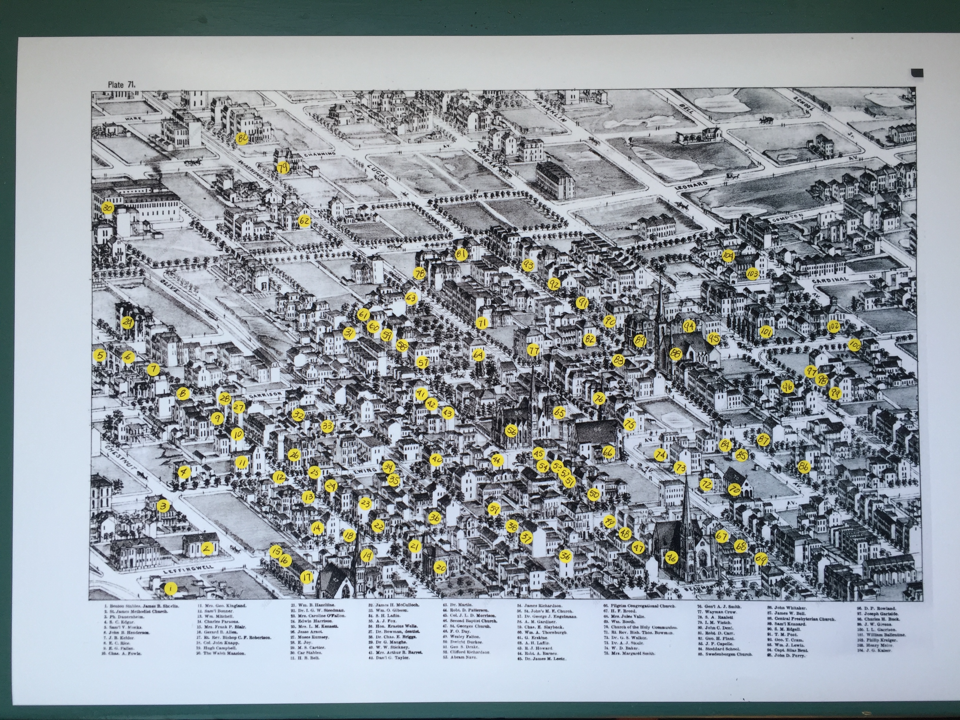
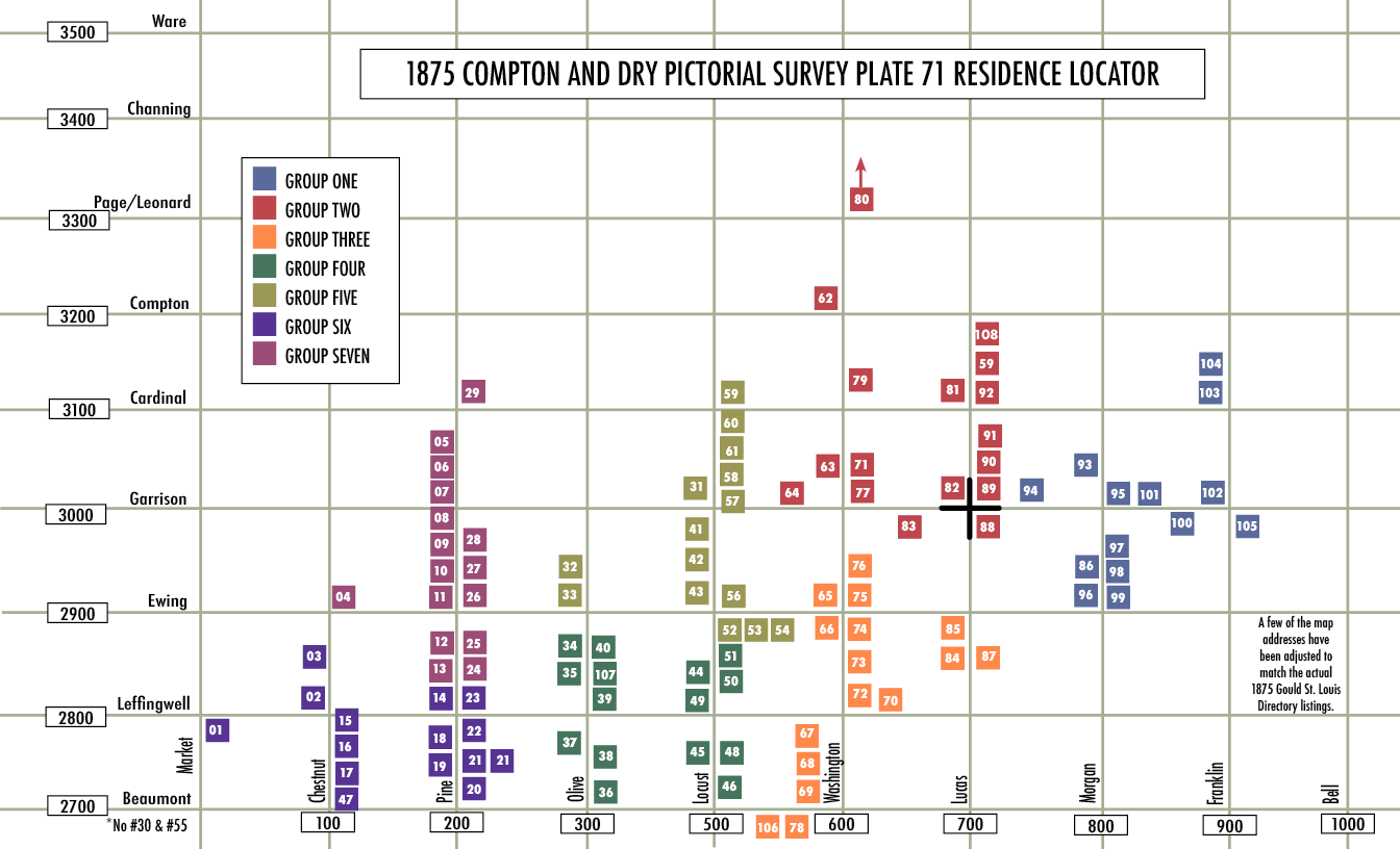
| 1 | 6 | Benton Stables | Market/Leffingwell | 53 | 5 | Nave, Abram | 2817 Locust |
| 2 | 6 | St. James Methodist Church | Chestnut/Leffingwell | 54 | 5 | Richardson, James | 2827 Locust |
| 3 | 6 | Dauernheim, Philip | 2822 Chestnut | 56 | 5 | St. Johns M.E. Church | Locust/Ewing |
| 4 | 7 | Edgar, S. C. | 2901 Chestnut | 57 | 5 | Engelmann, Dr. George J. | 3003 Locust |
| 5 | 7 | Monks, Samuel V. | 3014 Pine | 58 | 5 | Gardiner, A.M. | 3007 Locust |
| 6 | 7 | Henderson, John B. | 3010 Pine | 59 | 2 | Slayback, Charles E. | 3107 Lucas |
| 7 | 7 | Kehlor, J. B. (Duncan) | 3002 Pine | 60 | 5 | Thornburgh,William A. | 3023 Locust |
| 8 | 7 | Rice, E. C. | 2934 Pine | 61 | 5 | Erskine, Greene | 3015 Locust |
| 9 | 7 | Pallen, E. G. | 2916 Pine | 62 | 2 | Laffin, A.H. | 3216 Washington |
| 10 | 7 | Fowle, Charles E. | 2908 Pine | 63 | 2 | Howard, Richard .J. | 3036 Washington |
| 11 | 7 | Kingland, Mrs. George | 2902 Pine | 64 | 2 | Barnes, Robert | 521 Garrison |
| 12 | 7 | Bonner, Samuel | 2828 Pine | 65 | 3 | Leete, Dr. James M. | 2912 Washington |
| 13 | 7 | Mitchell, William | 2814 Pine | 66 | 3 | Pilgrim Congregational Church | Ewing/Washington |
| 14 | 6 | Parsons, Charles | 2804 Pine | 67 | 3 | Breed. H.F. | 2720 Washington |
| 15 | 6 | Blair, Mrs. Frank | 2737 Chestnut | 68 | 3 | Valle, Jules | 2710 Washington |
| 16 | 6 | Allen, Gerald B. | 2735 Chestnut | 69 | 3 | Booth, William | 2702 Washington |
| 17 | 6 | Robertson, Rt. Rev. Bishop C.F. | 2727 Chestnut | 70 | 3 | Church of the Holy Communion | Leffingwell/Washington |
| 18 | 6 | Knapp, Colonel John | 2732 Pine | 71 | 2 | Bowman, Rt. Rev. Bishop | 3029 Washington |
| 19 | 6 | Campbell, Hugh | 2728 Pine | 72 | 3 | Walker, Dr. G.S. | 2800 Washington |
| 20 | 6 | Walsh, John A. | 2721 Pine | 73 | 3 | Steele, Dr. Aaron.J. | 2825 Washington |
| 21 | 6 | Hazeltine, William B. | 2731 Pine | 74 | 3 | Baker, William D. | 2831 Washington |
| 22 | 6 | Steedman, Dr. I.G.W. | Pine/Leffingwell | 75 | 3 | Smith, Mrs. Margaret | 2901 Washington |
| 23 | 6 | O’Fallon, Henry | 2813 Pine | 76 | 3 | Smith, General Andrew .J. | 2911 Washington |
| 24 | 7 | Harrison, Edwin | 2825 Pine | 77 | 2 | Crow, Wayman | 603 Garrison |
| 25 | 7 | Kennett, Mrs. L.M. | 2835 Pine | 78 | 3 | Ranlett, Seth .A. | 2670 Washington |
| 26 | 7 | Arnot, Jesse | 203 Ewing | 79 | 2 | Veitch, Isaac M. | 3117 Washington |
| 27 | 7 | Rumsey, Moses | 2925 Pine | 80 | 2 | Dent, John C. | 3407 Washington |
| 28 | 7 | Joy, E. | 2929 Pine | 81 | 2 | Carr, Robert E. | 3130 Lucas |
| 29 | 7 | Cartier, M.S. | 3101 Pine | 82 | 2 | Plant, George H. | 3008 Lucas |
| 31 | 5 | Belt, H.B. | 3016 Locust | 83 | 2 | Capelle, John.P. | 620 Garrison |
| 32 | 5 | McCulloch, James H. | 2926 Olive | 84 | 3 | Stoddard School | Lucas/Ewing |
| 33 | 5 | Gibson, William O. | 2922 Olive | 85 | 3 | Swedenborgen Church | Lucas/Ewing |
| 34 | 4 | Laflin, S.H. | 2848 Olive | 87 | 3 | Bell, James W. | 2819 Lucas |
| 35 | 4 | Fox, A.J. | 2828 Olive | 88 | 2 | Central Presbyterian Church | Lucas/Garrison |
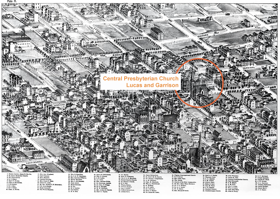
| 36 | 4 | Wells, Honorable Erastus | 2725 Olive | 89 | 2 | Kennard, Samuel | 703 Garrison |
| 37 | 4 | Bowman, Dr. George A. | 2731 Olive | 90 | 2 | Edgell, S.M. | 3015 Lucas |
| 38 | 4 | Briggs, Dr. Charles E. | 3735 Olive | 91 | 2 | Post, Rev. Truman .M. | 3031 Lucas |
| 39 | 4 | Maughs, Dr. M. B. George | 2801 Olive | 92 | 2 | Cram, George T. | 3103 Lucas |
| 40 | 4 | Stickney, William .W. | 2841 Olive | 93 | 1 | Lewis, William J. | 3014 Morgan |
| 41 | 5 | Barret, Mrs. Arthur | 2930 Locust | 94 | 1 | Bent, Captain, Silas | 717 Garrison |
| 42 | 5 | Taylor, Daniel G. | 2920 Locust | 95 | 1 | Perry, John D. | @3001 Morgan |
| 43 | 5 | Martin, Dr. Meredith | 2914 Locust | 96 | 1 | Rowland, David .P. | 2910 Morgan |
| 44 | 4 | Patterson, Robert D. | 2828 Locust | 97 | 1 | Gartside, Charles E. | 2923 Morgan |
| 45 | 4 | Morrison, Col. J.L.D. | 2740 Locust | 98 | 1 | Buck, Charles H. | 2917 Morgan |
| 46 | 4 | Second Baptist Church | Beaumont/Locust | 99 | 1 | Givens, J.W. | 2909 Morgan |
| 47 | 6 | St. Georges Church | Beaumont/Chestnut | 100 | 1 | Garrison, Isaac .L. | 816 Garrison |
| 48 | 4 | Day. F.O. | 2737 Locust | 101 | 1 | Ballentine, William | 803 Garrison |
| 49 | 4 | Fallon, Wesley | 2800 Locust | 102 | 1 | Krieger, Philip | Garrison/Franklin |
| 50 | 4 | Durkee, Dwight | 2803 Locust | 103 | 1 | Meier, Henry | 3104 Franklin |
| 51 | 4 | Drake, George S. | 2807 Locust | 104 | 1 | Kaiser, John .G. | 3110 Franklin |
| 52 | 5 | Richardson, Clifford | 2811 Locust | 105 | 1 | Sherman,William Tecumseh | 912 Garrison |